Bates County Cemetaries
Click to view The Historic Markers of Missouri
Civil War Markers, Jackson Cemetery/Amoret, MO
Homer Township, Section 22- Bates County, MO
Located appox. 1-1/2 miles from Spy Mound, approx. 2-1/2 miles from John Brown Mound/Massacre Park (KS
Wm. Payne CO H 7 ILL. INF.
Jesse Feeback CO G KY CAL.
Elam Mills CO H 7 ILL. INF.
Jos. A. Wilson CO G 115 IND. INF.
Wm. Conway CO D 147 IND. INF. (Buried by Phobe&Laura Conaway)
John Stephenson CO C 5 MO S.M. Calvary
Thos. Wright CO L 11 MO CAV.
Thomas Lackey CO G 72 IND. VOL. INF. (B. 1/21/1838 D. 6/14/1911)
Bates County Cemetery Information
Bates County, MIssouri has 34 registered cemeteries. The chart below will provide you with location information from various intesections in the county. We’ve also included latitude and longitude coordinates if you use a GPS system.
For additional cemetery info also visit: http://www.cemetery.poplarheightsfarm.org/
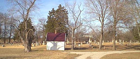
Johnstown Cemetery – Photo courtesy Poplar Heights Farm www.poplarheightsfarm.org.
Use the FROM INTERSECTION column to drive to the area of the cemetery, or use the LAT/LON information with your vehicle GPS Unit (Garmin, Tom Tom, etc.) to drive directly to the cemetery. Also, use Google Earth or Google Map. Simply highlight the LAT/LON numbers, copy and paste to the Google search. A map will then show the location and directions can be printed.
Click here for a handy printable copy of this chart in PDF format >>>
CEMETERYNAMELOCATED ON ROADAPPROX. DISTANCEDIRECTIONFROM INTERSECTIONLATLON
| Cemetery Name | Located on Road | Approx. Distance | Direction From | Intersection | Lat | Lon |
|---|---|---|---|---|---|---|
| ANTIOCH | HWY BB | 1/4 MILE | SOUTH | HWY BB & HWY D | 38.30999 | 94.12642 |
| ASHLEY | 1001 | 1/4 MILE | NORTH | ROADS 2 & 1001 | 38.22480 | 94.36894 |
| BENJAMIN | HWY 52 WEST | 230 FEET | WEST | ROAD 2001 & HWY 52 WEST | 38.25453 | 94.57029 |
| BETHEL | 8004 | 1/2 MILE | WEST | HWY BB & ROAD 8004 | 38.33295 | 94.17169 |
| BURDETTE | HWY FF | 103 FEET | SOUTH | HWY FF & ROAD 15002 | 38.44030 | 94.48227 |
| CLOUD | 12004 | 1/2 MILE | WEST | ROAD 12004 & HWY T | 38.39107 | 94.18664 |
| CRESCENT HILL | 14002 | 1/4 MILE | EAST | ROADS 14002 & 1001 | 38.42363 | 94.35736 |
| DOUBLE BRANCH | 3506 | 1/4 MILE | EAST | HWY N & ROAD 3506 | 38.16722 | 94.24889 |
| GERMAN REFORM | 7586 | 1 MILE | WEST | HWY O & ROAD 7586 | 38.10741 | 94.19235 |
| GREEN LAWN | HWY A | 1/8 MILE | EAST | HWY PP & HWY A | 38.09851 | 94.38551 |
| HOWELL | 7521 | 1/2 MILE | NORTH | ROADS 6002 & 7521 | 38.31602 | 94.48572 |
| HUME | 8508 | 220 FEET | EAST | ROADS 13007 & 8508 | 38.10306 | 94.58860 |
| INDEPENDENCE | HWY V SOUTH | 250 FEET | NORTH | HWY V SOUTH & ROAD 6508 | 38.13203 | 94.56036 |
| JACKSON | HWY 52 WEST | 220 FEET | EAST | HWY 52 WEST & ROAD 12001 | 38.25447 | 94.56876 |
| JOHNSTOWN | 14453 | 375 FEET | NORTH | HWY D & ROAD 14453 | 38.30988 | 94.08151 |
| MYERS | 10695 | 3/4 MILE | SOUTH | HWY 52 EAST & ROAD 10695 | 38.20376 | 94.15384 |
| MORRIS | 2701 | 3/4 MILE | NORTH | ROADS 3 & 2701 | 38.23171 | 94.40074 |
| MULBERRY | 4502 | 1/2 MILE | WEST | ROADS 11001 & 4502 | 38.29047 | 94.56110 |
| OAK HILL | EAST MILL ST | 150 FEET | WEST | HWY H & ROAD 1763 | 38.26343 | 94.31754 |
| PARK | 4721 | 1/4 MILE | NORTH | HWY TT & ROAD 4721 | 38.29924 | 94.43529 |
| PLEASANT GROVE | 6576 | 1/2 MILE | WEST | HWY P & ROAD 6576 | 38.11929 | 94.08137 |
| POAGE | 9004 | 1/4 MILE | WEST | HWY OO & ROAD 9004 | 38.34584 | 94.10422 |
| PRAIRIE CITY | HWY O | 1/2 MILE | SOUTH | HWY B & HWY O | 38.08514 | 94.17720 |
| RADFORD | HWY H | 1/4 MILE | EAST | HWY H & ROAD 10623 | 38.26289 | 94.14890 |
| MEYERS | 10356 | 3/8 MILE | EAST | ROADS 15305 & 10356 | 38.06411 | 94.06776 |
| RODGERS | 2116 | 3/4 MILE | WEST | HWY O & ROAD 2116 | 38.18792 | 94.19434 |
| SAINT BRIDGES | HWY A | 1/8 MILE | EAST | HWY PP & HWY A | 38.09858 | 94.38553 |
| SMITH | 2004 | 1/4 MILE | WEST | ROADS 9503 & 2004 | 38.24591 | 94.17854 |
| SNODGRASS UNION | HWY H | 1/8 MILE | WEST | ROAD 14853 & HWY H | 38.25870 | 94.07553 |
| STRATTON/BLACKWELL | 3066 | 2 1/4 MILES | WEST | ROAD 3066 & HWY W | 38.17083 | 94.11657 |
| VIRGINIA | 6001 | 1/4 MILE | NORTH | HWY 52 E & ROAD 6001 | 38.26889 | 94.45917 |
| WEST POINT | 12002 | 1/2 MILE | WEST | HWY Y & ROAD 11002 | 38.38467 | 94.59753 |
| WHITE | 4004 | 1/2 MILE | WEST | ROADS 9503 & 4254 | 38.27865 | 94.18231 |
| WOODFIN | V SOUTH HWY | 3/4 MILE | NORTH | HWY V SOUTH & HWY U | 38.18455 | 94.53023 |